
East Peak of Broads Fork Twin Peaks. Viewed from the saddle below Sunrise.
Very few people in this world know what what it’s like to not have to wear a uniform for work. At some point in our lives, unless you’re Donald Trump or Prince William or the fortunate (or unfortunate) heir to a nudist colony empire, you know what it is to have a job that requires a name tag and some sort of smock, apron or, in my case, a green REI vest. The purpose of the vest is two-fold: provide pockets and loops for any assortment of pens, pads, pins and paraphernalia and also provide customers a clear and unmistakable indicator of which people in the store they can ask questions without feeling self-conscious or intimidated.
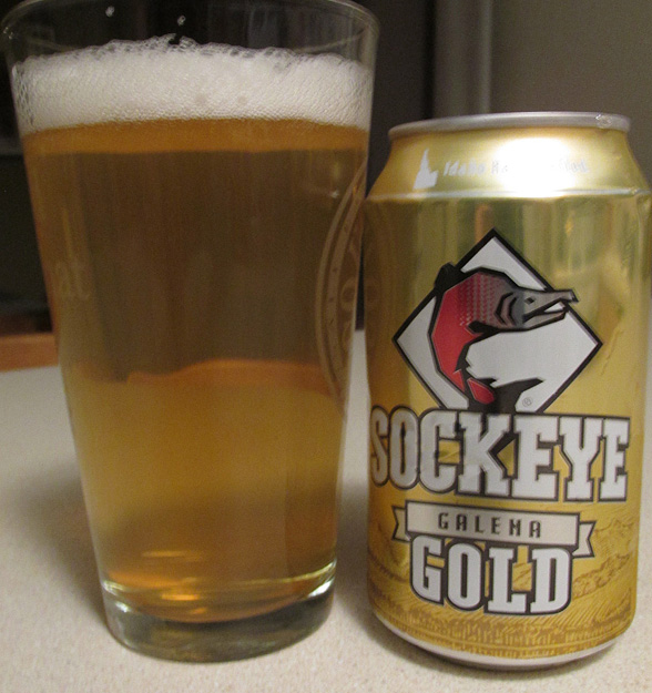
The choice for my highest summit of 2015, Sockeye’s Galena Gold Kolsch style.
As my wife has observed, when it comes to queries from strangers at the trailhead, I’m figuratively still wearing that green vest. Perhaps it’s the clothes I wear that suggest I know what I’m doing. Inadvertently, I have shown up at the trailhead sporting a yellow shirt/brown hat combination that made me look like an on-duty forest service employee. Guess I have to blame myself for that one. Then there is the severe over-preparation I seem to undertake in the parking lot as I prepare to disembark for even the most inane hikes. Even for a short day hike, I will often load a 45 liter pack with maps, first aid kit, rain gear, and headlamps which likely makes other hikers assume I take things way too seriously. If they also saw me loading the beer and flasks, observers might think twice about trusting my council. Finally, I think there is this non-threatening aura I give off that makes people gravitate towards me whenever their disorientation is jeopardizing the the enjoyment of their hike. I’m the equivalent of the average, non-muscle head at the gym that no one worries about asking if they are done with the bench. I’m not threatening, I don’t give off an attitude, but I don’t appear to be an idiot either.
And so it happened a few Sunday mornings past at the Mill B South Fork trailhead as I was preparing for a hike up Broads Fork. A solitary man in a red shirt called out, “Excuse me,” at least twice while I was angrily back at my car grabbing my forgotten sunglasses after starting up the trail once already. While I zipped up my pack, I thought, “Green Vest Gravity strikes again”. The guy was pleasant enough and just wanted to know the way to the Broads Fork trail. Since I expected most people in this lot were likely heading up the Lake Blanche trail, (a far more scenic and reasonable hike), I did have a brief thought of disappointment as I imagined Broads Fork being equally crowded, but I explained to him how the Broads Fork trail starts up the Lake Blanche trail and then eventually splits off on its own.

An expansive, birds-eye view of Little Cottonwood canyon is just one of the rewards for climbing Broad’s Fork Twin.
“I’m pretty sure it’s marked,” I said, “but it has been a while since I’ve hiked it.” That disclaimer would be prophetic because, in fact, the trail to Broads Fork leaves the parking lot in the exact opposite direction as the Lake Blanche trail, a fact I realized about 15 minutes into my second hike up the trail. I was on the wrong side of the divide between Mill B and Broads and had to turn around a second time. I finally started my hike up the actual Broads Fork trail with my frustration over the 30+ minute compounded by the anxiety of how I likely ruined that guy’s day by sending him up the wrong trail.
I’m going to open up to the public a bit here and share the fact that I cannot let shit like that go. All I could think of is how I steered him wrong and what must he think of me. I tried to convince myself that eventually, any good hiker would figure it out and turn around. If he didn’t, then he probably shouldn’t be hiking Broads. How’s that for rationalizing? The thought of him getting all the way to Lake Blanche before figuring it out ate at me for about 45 minutes up the trail. Eventually though, I was able to lose myself in the moment. I hadn’t seen anyone since the trailhead and the solitary, narrow path was so overgrown in some spots that you really couldn’t spot your footing. The bushes, still wet from the previous day’s rain, were cool and made the summer’s 100 degree days down in the valley seem like they took place on another world.

Upper Broads Fork. From left to right, Dromedary, Sunrise and the East Twin.
My goal for the day was the Twin Peaks of Broads Fork (not to be confused with American Fork – Twin Peaks near Snowbird). The west peak of this Wasatch mountain is one of the more prominent peaks visible from the Salt Lake Valley. As one scans the Wasatch front from north to south, the front ascends between each major canyon; Grandeur, Olympus, Twin and Lone. Lying on the Cottonwood ridgeline, these twin summits are clearly visible from my kitchen window in Sandy and ever since I moved in to my new home in May, I felt they had to be the next peaks I bagged in the Wasatch. The east peak is the highest at 11,330′, but the west twin is only 2′ lower. The Broads Fork route approaches from the east on a long steep hike to the east peak, making the west peak an “icing on the cake” if I made the summit, Since the west peak was the more visible spire from my home perspective 7,000′ below, I was hopeful I could bag them both.
90 minutes in, I started to reach the upper limits of Broads Fork and was treated to a beautiful view of the additional peaks that crowned its cirque: Dromedary and Sunrise which lie just east of east Twin. These dark and defined summits, while lower than Twin, seemed more menacing when compared to the triangular nature of the east Twin, yet by no means would it be an easy hike. I was already prepared for things to get tough. From the get go, there really is no respite on the pitch of the Broads Fork trail and I was already dreading the steep hike down, but once I passed the head of the stream, I realized the challenges had yet to really start. In the bowl below the three a fore mentioned peaks was a long talus field that made me thankful I brought trekking poles. While talus is a part of almost any mountainous hike, this field had a particularly nasty mix of small rocks on steep slopes on which my footing always seemed to be slipping. There was also a bumper crop of prickly thistle weeds that had a knack of growing right where you wanted to step.
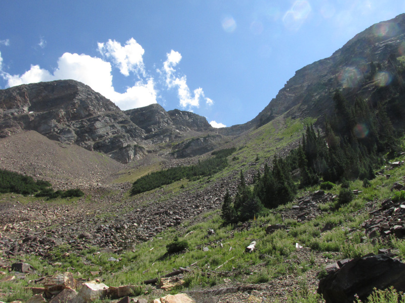
Over 1,000′ of steep talus to the saddle makes Broads Fork twin one of the more time consuming climbs in the Wasatch,
At the top of the talus was a saddle at 10,800′, between Sunrise and Twin and I encountered another barrier, a narrow ridge with angular jumbles of rocks shooting out tow either side and and falling off sharply before meeting a small rock spire that blocked the route. This minor cliff required a short climb in order to continue on to the base of the peak. I couldn’t quite tell what other options I had, so I convinced myself to keep going, (at least until I couldn’t go any further), rather than talk myself out of the climb before I even tried.
As worked my way along larger boulders on the saddle, I began to sense that a trail did drop of the ridge somewhat to the left (south) and run along the base of the cliff where it met the slopes above Lisa Falls, but I still couldn’t see any spot where you could get back on to the ridge; the rock only seemed to get more sheer and higher. Around this time, I saw a large group of people coming down from the peak. I’m not sure how I was able to make this judgement given they were so far away, but I felt if they were able to make it over this obstacle, then so could I. I took my time climbing around to the south side of the ridge and by then, some of the descending hikers were above me looking for a way to downclimb the cliff back to the saddle. None of them seemed too certain of the route and there was a lot of discussion and second guessing, but eventually they were finding a route. Then I started seeing hikers coming towards me at my level, not from above. One of the hikers mentioned a chute further ahead that could be hiked if I didn’t feel like scaling the wall. Deciding that the path of least resistance was the best bet since I was alone, I continued on below the ridge staring down awestruck at the uninterrupted slope above Lisa Falls. This long chute slides 4,000′ down to the floor of Little Cottonwood Canyon. Thanks to that perspective, a simple traverse along relatively solid and level ground seemed much hairier. However, I felt better when I saw a red-shirted hiker come out from the chute I was seeking. I realized that hiker was the same guy I gave bad directions to in the parking lot. As I passed him, I asked, “Are you the one I gave bad info to in the parking lot?” He sure was, and he explained a quick glance at the trailhead map helped him realize my error long before I figured it out. Climber Karma was swung back in my direction.
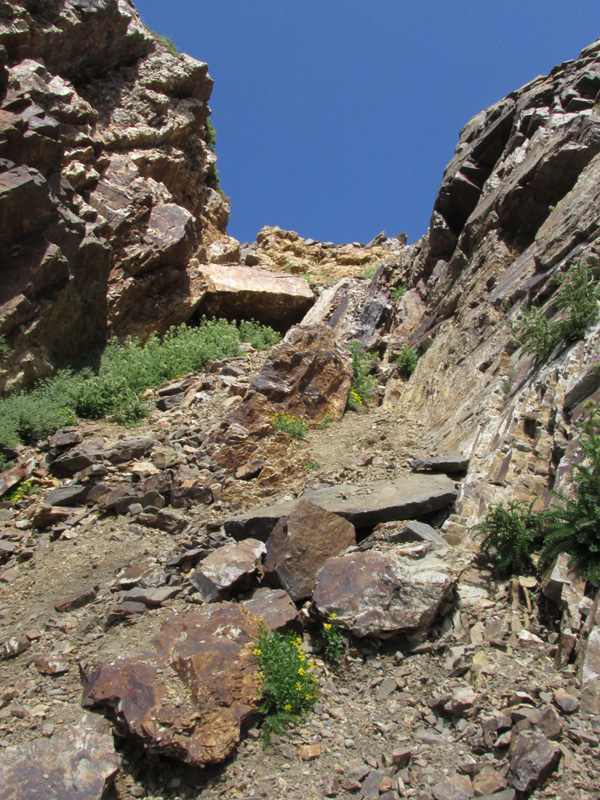
While difficult in it’s own right, this chute on the L. Cottonwood side of the saddle is am alternative to climbing over some minor cliffs on the ridge.
Climbing the chute back up to the ridge wasn’t easy due to lots of loose, small rock and waiting for others to descend the narrow 100 vertical feet since falling rocks would pose danger for those below. The scrambling eventually got me back to the trail at the base of the peak as it switchbacks up the slopes of the east twin. From that point, the remainder of the climb is steep, but pretty elementary; not even a false summit to dash your spirits like so many other climbs. Once on the top, I was fortunate to have the mountain top all to myself. I looked over at the west twin and decided, at that point, I would be satisfied with summiting just the higher of the two peaks. Rather than add more hiking to my day, I would sacrifice the two-for-one in exchange for a few extra moments on the highest point of the Cottonwood ridgeline to enjoy my summit brew, a Sockeye Brewing Galena Gold.
Anyone familiar with the central mountains of Sockeye’s native Idaho knows that Galena Pass marks the divide between the Wood River Valley (home of Sun Valley) and the Sawtooth Valley, home to some of the most picturesque mountains in the west. A light, refreshing Kolsch in a can with a modest alcohol content seemed like the perfect choice for a peak where I would want all my wits about me for the descent.

More deliciousness in a can, courtesy of Idaho. Sockeye’s Galena Gold.
I feel like Kolsch’s are and underrated beer. When you want a summer style beer that is crisp and light, the answer these days seems to be, “put some fruit in it”, but a Kolsch gives you those same refreshing qualities while still tasting like a beer. The malty bouquet doesn’t get overdone in the taste. You smell it, but but it doesn’t hijack the taste if that makes sense. Instead, you taste the essentials of what makes “beer” beer, a little grain, a little hops, a little yeast, and of course clean, refreshing water, like it was just brewed out of the Salmon River itself. OK, maybe I’m going a little far, but as the temperature was beginning to warm, even this barely cool beer that had been in my backpack for 5 hours tasted incredibly refreshing. The smoothness of the beer is it’s main characteristic, but there is just a bit of spice at the back of it to make it unique. Watching it in a glass against the light and seeing the bubbles rise to the top, you almost feel like a miner catching a shimmer of gold dust in his pan as he works his claim. A really drinkable summer beer that doesn’t have that overbearing carbonation that usually stricken Kolsch’s.
With such close proximity to the valley floor and being the highest point on the Cottonwood ridgeline, Twin Peaks gave me yet another new perspective on the Central Wasatch. From Coalpits to Baldy, I was looking across at every detail of Little Cottonwoods southern drainages like never before. Only birds had a better view than me that day. And if the view of the surrounding Wasatch wasn’t enough, I could also look westward into Salt Lake and survey the patchwork of major streets and large retail complexes to help locate the Fort Union area. Somewhere, in a cluster of residential streets was my home in Sandy. Hardly 4 months in our possession, I’ve learned to appreciate the nearly perfect view of Twin Peaks I have from my deck. (I say “nearly” because perfect wouldn’t include my neighbors swamp cooler and satellite dishes, but that’s a small blemish when I think of the view at our old condo, a grassless strip of lawn separating our property from an apartment complex.)
While the elevation of Twin Peaks doesn’t quite qualify as one of the highest in the Wasatch there are, (depending on whether or not you count multiple peaks of a single mountain as individual high points or not)at least 5 mountains in the Wasatch Higher. However, the climb to to the East Twin of Broads Fork covers over 5,000′ in elevation gain. That dwarfs the commonly used route to Nebo (the highest in the Wasatch) and makes Timpanogos seem easy in comparison. While Timp is a long day, you hike a pretty solid, well worn trail the whole way and your elevation gain is about a 1,000′ less than the Twin climb. I was feeling pretty accomplished as I made a quick note in my journal that I was choosing not to summit the west peak. Then I remembered how painful that descent would be. Non-stop stabbing of the legs into the ground as you tried to brace your steps against the steepness of the trail while probing for a solid spot to plant your trekking poles as you awkwardly try to save whatever is left of your knees. As I considered the pain of the descent, I was looking out at a pretty rudimentary scramble to the second peak, the true Twin Peak from the perspective of my backyard. So before even finished writing my turnback time in my journal, I wrote, “Fuck it,” and started west.

“I can see my house from here!” The view west from the West Twin.
Next time… ski it!